Posts

Showing posts from February, 2013

Esplanade Hotel

Image
The Esplanade Hotel is an imposing three storey plastered brick building. Its three-sided facade is aligned so that the Hotel entrance faces Victoria Road - Queens Parade junction. The hotel was built by the Great Northern Brewery Company Limited on the former site of Holmes Brothers 'Flagstaff Hotel', which had opened in August 1864. The old hotel was moved to an adjacent site in Queens Parade, so that the new hotel could be built. The old wooden building was used as a staff residence and boarding-house until it was demolished in 1938. Ref: D_GSV-0009, Esplanade Hotel, c. 1909, North Auckland Research Centre

Great Auckland Exhibitions

Image
A world fair was held in 1898 in Auckland's Domain, in the heart of the city. The Auckland Industrial and Mining Exhibition opened on 1st December 1898. The industrial courts were a described in an Australian newspaper (the Inquirer & Commercial News (Perth, WA), Friday 9 December 1898, p.2) at the time as a 'credit to the colony, the exhibits of mineral and woollen goods being particularly fine'. Ref: AWNS-180528-4-2, Auckland exhibition drawing plan 1898, Sir George Grey Special Collections The buildings of the exhibition covered a large area of about 5 acres on  part of what was the Old Government House grounds. The main entrance to the building was in Princes Street. The exhibition was divided into six sections — industries, products, machinery, mining and minerals, art and music, athletic sports, and competitions.

Chinese communities in Auckland

Image
To celebrate Chinese New Year (also see the earlier post on 21 January 2013), we have been busy pinning up great heritage photos on Historypin. The images show locations and activities in Auckland associated with Chinese communities. The collection of images on Historypin  has two parts. The first is Old Chinatown in the centre of Auckland, around Greys Avenue, Hobson and Cook Streets. The first shop and business in this area was recorded in 1895. Other shops and businesses as well as a mission hall, masonic lodge and housing were quickly established. The images chosen show key locations in Old Chinatown, a landscape which will be both familiar and unfamiliar to present day Aucklanders. In an attempt to 'clean up the area', by 1964 Old Chinatown had been demolished to make way for new developments such as Myers Park, council flats and Auckland Town Hall. Ref: 4-2212, Chinese Mission Hall, Sir George Grey Special Collections

The Waikato War

Image
Discover New Zealand's past by travelling in the path of the Waikato War 1863-1864 . Hamilton and Waikato Tourism have teamed up with the New Zealand Historic Places Trust (NZHPT) to create a interactive way for people to understand and 'experience' the Waikato War. As NZHPT archaeologist Nigel Prickett says, 'The best way of understanding what happened at these places is to go there". The website is split into historical content and driving tour information including further information about key sites. The driving tour includes 13 major historical sites to visit along the way from Highwic in Auckland to Alexandra Redoubt in Pirongia. Ref: 435-C545, Highwic, Sir George Grey Special Collections

The wreck of HMS Orpheus

Image
If you ever fancy a nice weekend drive in Auckland the perfect place to go would be the Awhitu Peninsula, north of Waiuku. You can pack a picnic, take a dip in the sea, go camping at the Awhitu Regional Park , or just enjoy a drive. Ref: AWNS-19020925-5-4, Mokohinau lighthouse, Sir George Grey Special Collections Any trip to Awhitu, however, just has to include a visit to the restored lighthouse on top of the Manukau Heads over looking the entrance to the harbour.  It is there that one can walk out on to the balcony and look across to the Waitakere Ranges on the northern side, and imagine what it must have been like on a particular day 150 years ago  for an 18-year old signalman by the name of Edward Wing as he guided in the British warship HMS Orpheus, only to see it crash on to the infamous sandbar. Of the 259 assumed to be on board that day, 189 seamen perished, some as young as 14 years old, many of them not able to swim. This is still New Zealand's worst maritime disast

Signing the Treaty of Waitangi in the Auckland area

Image
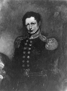
On 6 February 1840 the Treaty of Waitangi was signed in the Bay of Islands. Lieutenant-Governor William Hobson afterwards circulated copies of the treaty for signature by other chiefs throughout New Zealand. Over the next few months five or six treaty meetings were held in the Waitemata and Manukau areas. Ref: 4-1351, William Hobson, Sir George Grey Special Collections The first of these was held during Hobson’s first visit to the Waitemata, on 4 March 1840. The exact location is uncertain, but was probably Karaka Bay , and if not Karaka Bay then certainly somewhere along the shoreline between the Tamaki River and Maraetai. Sixteen Ng āti Paoa, Ng āti Maru and Ng āti Tamater ā – and perhaps also Ngai Tai – chiefs signed a copy on this occasion, with Captain Joseph Nias and the missionaries Henry Williams and William Fairburn acting as witnesses.

Pinning cows!

Image
A Historypin Pin of the Day image showing Henry Thomas and his children seated on and standing beside a cow, recently caught my eye. The image is originally from the Wairarapa Spydus Archive and was pinned by the DairyNZ Time Capsule Project . The project is a nationwide initiative for NZ Year 5-8 students. The project aim is to create an online time capsule of the NZ Dairy Industry. Ref: Historypin 'Pin of the Day', 18.01.2013, Ref: 01-103/3.MD1111, Henry Thomas and family, Greytown New Zealand, 1900, Source: Wairarapa Spydus Archive, Pinned by: DairyNZ Time Capsule Project Auckland Libraries holds collections of  heritage photographs depicting cows and the dairy industry, including a similar image of a child sitting on a cow (see below). Many of these images can be accessed through Auckland Libraries' online heritage databases: Heritage Images , Footprints and Local History Online . Images depict locations from around the Auckland Region and further afield,

Pioneer Women’s and Ellen Melville Memorial Hall

Image
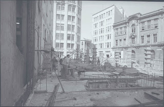
Many are surprised to learn that modern architecture can be ‘heritage’ too! It is important to preserve a range of building types and styles to hand on to future generations – not just the obviously old and pretty. The Pioneer Women’s and Ellen Melville Memorial Hall in Freyberg Square in Auckland’s CBD was completed in 1962 and designed by Tibor Donner (1907-1993). Donner was the Chief Architect of Auckland City Council from 1946-67 and designed many well-known public buildings , including our Civic Administration Building and Parnell Baths. Ref: 580-5695, Construction of the hall in 1961, Sir George Grey Special Collections